- Home
- Departments
- Departments G - Z
- Geographic Information Systems (GIS)
- FEMA Flood Insurance Rate Maps Information
FEMA Flood Insurance Rate Maps Information

The Federal Emergency Management Agency (FEMA) produces and continuously updates flood hazard data in support of the National Flood Insurance Program (NFIP).
The FEMA Flood Insurance Rate Maps (FIRMs) are the official maps showing the community's Special Flood Hazard Areas. Special Flood Hazard Areas (SFHAs) are areas located within the 100-year floodplain, defined as any area that has a one percent chance of flooding in any given year. These maps are utilized as the basis for local floodplain management regulations and mitigation efforts, to assess flood risk, and to determine if flood insurance is required for structure(s) on a property. The Digital Flood Insurance Rate Maps (DFIRM) is available to view online through FEMA.
Please Note: FEMA's flood maps are not property-specific (e.g., parcel or lot boundaries). If there is any doubt in determining whether your property is a flood risk, then the user should consult Plumas County's Planning Division for assistance, seek certified elevation data, or seek additional assistance from FEMA through their website (FEMA) or by calling 1-877-FEMA.
Viewing FEMA FIRM maps through FEMA's mapping application:
(Please Note: This Mapping application below is a public service for flood hazard information produced in support of the National Flood Insurance Program (NFIP). Plumas County does not provide this information and shall not be liable for any errors, omissions, or damages that result from inappropriate use of this information.)
Link to the Map below if you wish to view this map full-screen: https://msc.fema.gov/nfhl
Flood Safety Awareness and Preparedness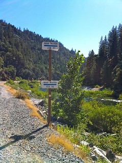
Floods can occur any time during the year but are especially prevalent after winter snow melts or heavy spring rainfall. Being prepared for a flood not only helps keep your family safe but can also help minimize potential flood damage and accelerate recovery efforts.
In January 1997, Plumas County experienced extensive flooding. Torrential rains washed out roads and bridges and sent many residents scurrying for safety. There were also long power outages and residents were unable to travel to areas where there was food due to the impassable roads.
Plumas County has seen the danger and damage floods caused throughout the County. Mitigation is the first step toward minimizing the impact of a flood or any disaster. Mitigation can be defined as making something less harmful or in this case, prevention.
Please visit Plumas County's Office of Emergency Services (OES) website for flood safety tips and precautions to help keep you and your family safe before, during, and after a flood.